Nieman Foundation at Harvard
It’s been a year since Haiti’s devastating earthquake, and news organizations have been finding creative and commendable ways to mark the sad anniversary. Some are going local, finding stories within their communities that bring the tragedy home; some are going meta, examining big-picture issues like technology and foreign aid as they relate to the crisis. And others are going back — to Haiti itself, to the scene of the quake, to paint a picture of how far the country’s come and how far it still needs to go.
Of this last group, The New York Times’s coverage stands out: The paper’s interactive team put together a fantastic interactive map of the devastation, allowing users to experiment with satellite images of Haiti before the quake, immediately after, and now.
The feature’s general awesomeness isn’t a surprise: Fairly or not, excellence from the team is pretty much an expectation at this point. What’s more remarkable than the graphic’s quality is its source: The interactive uses images from Google Earth and the earth imagery outfit GeoEye. And those images were offered by Google itself.
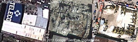
In advance of today’s anniversary, a rep from Google Maps and Earth reached out to news organizations, offering a downloadable, high-res photo album; before-and-after stills, hosted by a third party, of tent villages; and videos of before-and-after scenes, including Port-au-Prince’s Pétionville Golf Course-turned-tent camp (on both Quicktime HD and YouTube) and Haiti’s National Palace (Quicktime HD, YouTube). It also provided raw footage — of the Cathedral of Our Lady of the Assumption (July ’09, January ’10, November ’10), Haiti’s airport (July ’09, January ’10), its National Palace (August ’09, November ’10), and Pétionville (August ’09, November ’10) — and contextual info in the form of a collection of Lat Long blog posts describing the mapping efforts the outfit undertook throughout 2010.
On its own, none of that — Google’s provision of images and video, a news organization’s use of it — is a huge deal: News outlets regularly make good use of Google’s trove of information, for stories big and small. But, as an experiment in collaboration, the Times’s Google-fied cross-pollination is a small reminder of the benefit that can come when news organizations take advantage of resources that lay beyond the walls of their own newsrooms — finding ways of getting there without actually going there. As Sean Carlson, Google’s manager of news industry relations, explained to me: “We’ve heard that Google Earth and Google Maps can be like helicopters in the hands of any news organization.”
The images, videos, and background info are all still available for any news outfit that wants to use them. A good thing, because, today’s 365-day news peg notwithstanding, the story of Haiti’s devastation isn’t over. The quake created 20 million cubic feet of debris. A year later, only 5 percent of that has been cleared.